Returning Members? Click on the Icon |
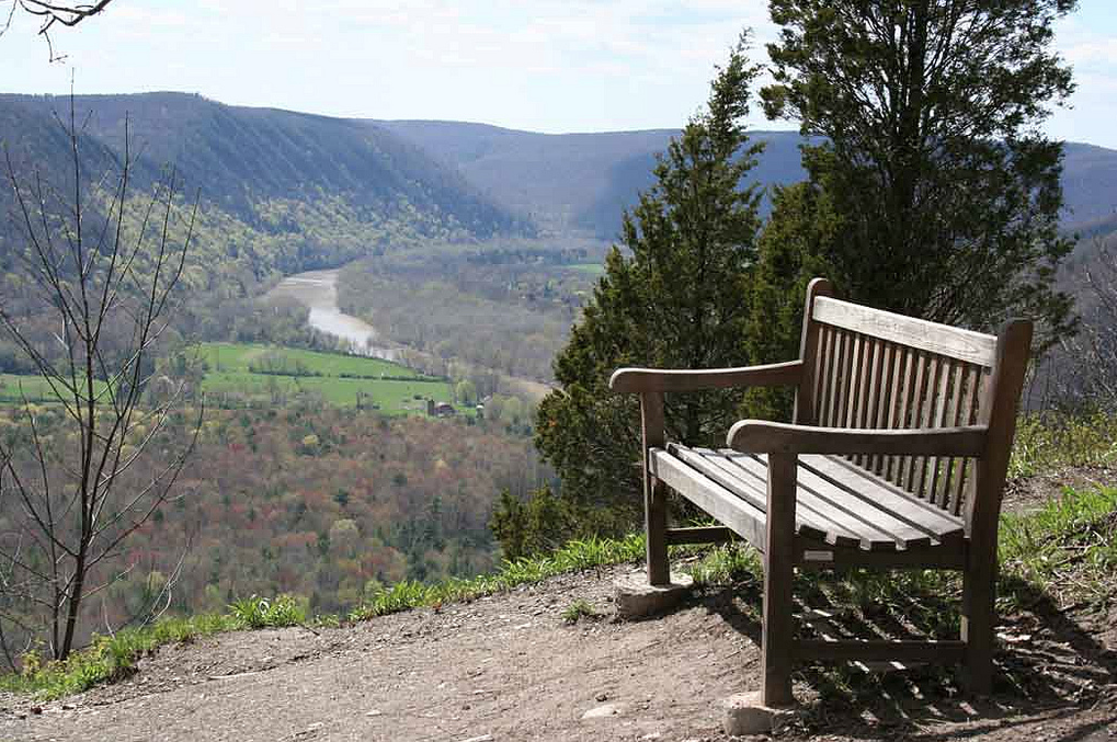
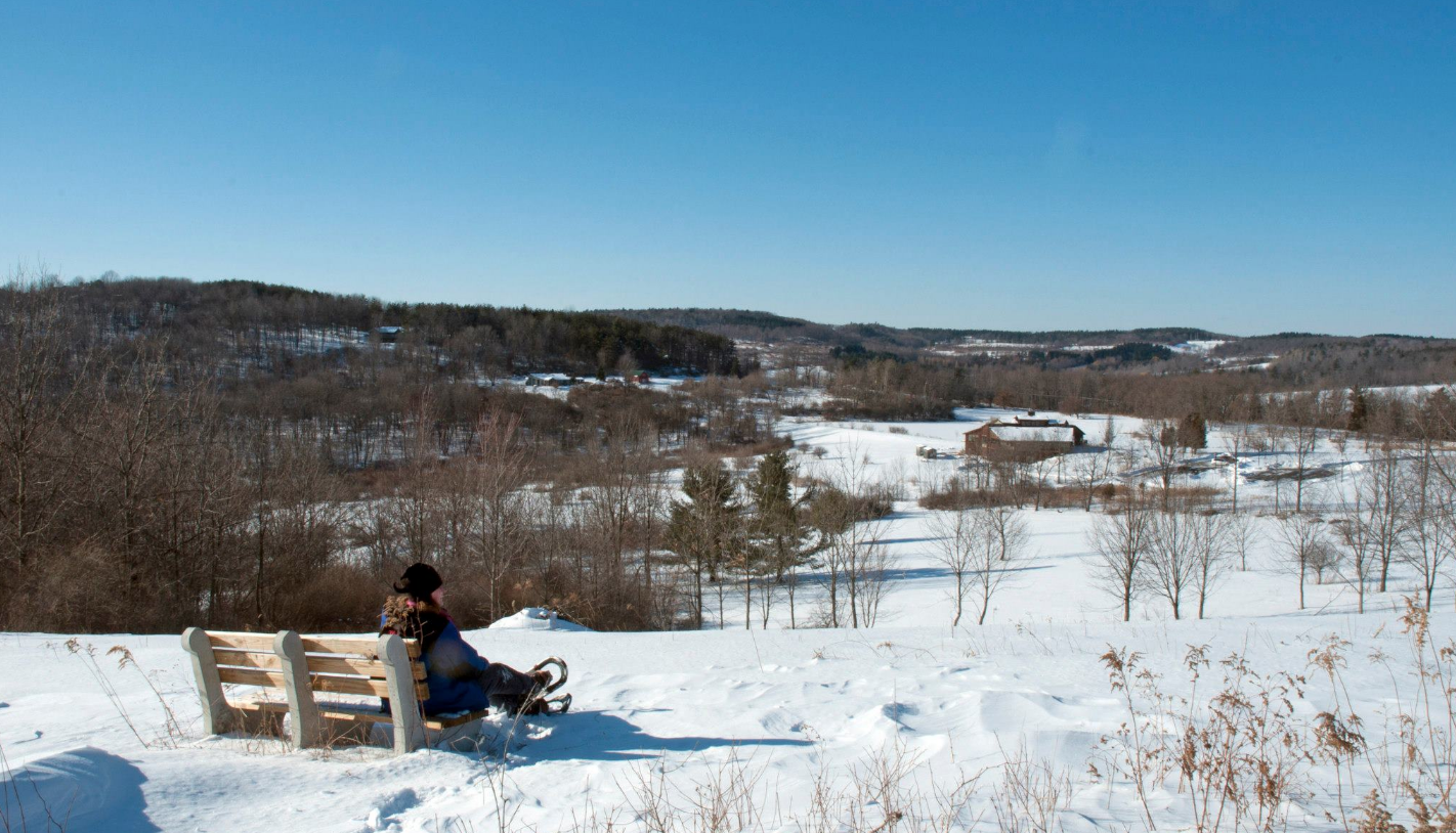
View from Gleason Meadows Red Trail Bluff.
Our trails are open to the public from dawn to dusk, for free, 365 days a year.
Trail Policies:
- Hikers should stay on mowed and designated trails. Timber rattlesnakes are legally protected on this site. While sightings are rare, caution should be exercised.
- Obey posted signs and do not enter any restricted areas. These areas are home to threatened and endangered animals and plants. Help us protect and preserve the species in this ecosystem - do not collect any plants, animals, or other specimens. Do not bring in and leave any plants or animals.
- Dogs are not permitted on the trails by or leading from the Nature Center, Gleason Meadows/Frenchman's Bluff.
- If you wish to hike with your dog (and we hope that you will!) please drive just two minutes down the road to our dog-friendly trail system, Personius Woods.
- No bicycles, horses, or motorized vehicles are permitted on the trails at either of our sites.
- No swimming, fishing, hunting, trapping, boating, skating is permitted at either site.
- No camping is permitted at either site.
Trail Maps: (scroll down to the PDF links to view maps)
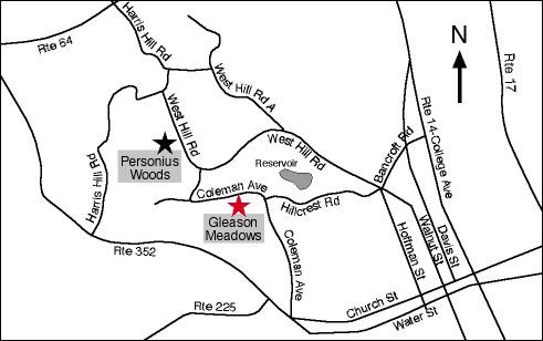
Gleason Meadows/Frenchman's Bluff. Map (PDF)
Gleason Meadows/Frenchman's Bluff is the trail system that we are best known for - these are the trails that depart from the Nature Center and are the "main" Tanglewood trails.
No dogs are allowed on these trails (with the exception of service animals).
To hike any of these trails, proceed to the trailhead kiosk. The trails diverge about 30 ft past the kiosk and 10-15 ft past the treehouse. You'll notice a big fork with trails going left, right, and straight ahead. The Pink peels off immediately in a hard left to mown meadow trails; the Yellow peels off immediately in a hard right and the trail heads downhill to the field. Straight ahead, the Blue, Red, and Yellow trails all overlap on what looks like "the main trail" heading straight out into the woods from the trailhead kiosk. (This wide, obvious section of trail is sometimes called "the farm road" or "the forest road" because it is wide and was used as an access road when this property was previously farmed.) The Blue, Red, and Yellow overlap for about a third of a mile and diverge at the next trail kiosk near the Gibbs memorial bench.
Trail descriptions:
- Purple (Children's Sensory Trail). 0.19 miles. This is a short, mulched loop trail. The trail begins under a trellis about 10 ft past the treehouse. The sensory trail has a storybook that is changed seasonally, with each page mounted on a different signpost, so that families can read the storybook as they walk down the trail. There are a variety of sensory stations along the way (scented herbs, a box of natural objects with different textures, musical instruments like glockenspiel and chimes) for families to explore. There are also imaginative stations (gnomes, fairy houses) and active areas (jump stumps, climbing wall, hammocks). This trail ends less than a quarter of a mile later, with the end of the trail immediately next to the trellis that begins the trail. Some visitors negotiate this trail with strollers but it can be a bumpy or a muddy ride depending on the amount of rain we've received and how much the rain runoff has rearranged the mulch!
- Yellow (Hoffman Tree Trail). 1.01 miles. This is a fairly short loop trail that departs down the mown grassy trail by our picnic pavilion, heads into the woods where the footing becomes quite rugged with many roots and rocks, and then returns to the trailhead after rejoining the blue and red trails near the Gibbs Memorial bench. There is about 100' of elevation change, although it is a gentle gradual change. Sections of this trail receive a lot of runoff when there is rainfall on the hill, so the trail can be quite muddy in parts. The western section of this trail winds through an area densely populated by dead and dying ash trees, so expect fallen limbs and logs.
- Green (President's Trail). 0.96 miles. This is a short grassy loop trail that must be accessed by either hiking the pink spur trail (steep uphill, through meadows) or the red/blue/yellow trail (less steep, wider and rockier old "farm road" through the woods). Either way, expect to hike at least a quarter mile to join the Green Trail. Once you are on the Green Trail, you're circling the top of the hill with sweeping views of the nature center and neighboring farms to the north, and expansive gorgeous views of the valley that was cut by glacial activity and the Chemung River to the south. That southerly view is inspirational in fall as the hillsides light up with fall foliage. The Green trail is mowed along the edge of a maintained meadow that preserves grassland habitat for ground-nesting songbirds like the meadowlark, bobolink, and grasshopper sparrow. Being a mown trail among meadow habitat, there is little to no shade. There is a small spur trail to the middle of the meadow where the Borrelli memorial bench is located for rest and reflection. The Green Trail has a variety of healthy exercise signs inspired by Elmira hero, Ernie Davis.
- Orange (Tanglefoot Trail). 1.51 miles. This trail must be accessed by hiking the pink & green, or red/blue/yellow & green trails. Either way, expect to hike at least half a mile to join the Orange Trail. Once you are on the Orange trail, you'll depart the meadows and head into a mixed oak-hickory and pine wood area. This section of trail will widen onto an old forest road/logging road before emerging into more meadow by the Boyd Pond area. There is a bench and an Eagle Scout three-sided shelter which can be a lovely place to rest and picnic. The views from the pond looking southeast over the meadows, Chemung river, and distant hills are beautiful. On a clear day, you can see for miles, into neighboring Pennsylvania.
- Pink (Whitetail Trail). 0.43 miles. This trail departs almost immediately behind the treehouse, the first left turn available to you about 10 ft after the treehouse stairs. It is a mown trail that traces the perimeter of a maintained grassland habitat. The steepest portion is the western side of the trail, which runs directly up hill towards the bench at the top of the hill, before joining the Green trail. The more gentle, gradual change in elevation is to take the eastern side of the trail (the side where the TV tower is) which heads out along the hedgerow that the treehouse sits in, meets the edge of the forest, and climbs up towards the bench parallel to the forest most of the way. The Pink trail encloses meadow so much of the trail is in full sun.
- Blue (Bluebird Trail). 1.70 miles. The Blue trail is a "lollipop loop" - a long spur trail that connects into a loop away from the trailhead. The Blue, Red, and Yellow trails all overlap on what looks like "the main trail" heading straight out into the woods from the trailhead kiosk. (This wide, obvious section of trail is sometimes called "the farm road" or "the forest road" because it is wide and was used as an access road when this property was previously farmed.) The Blue, Red, and Yellow overlap for about a third of a mile and diverge at the next trail kiosk near the Gibbs memorial bench. The actual loop part of the Blue trail largely overlaps with the red trail, so as you reach the kiosk near the Gibbs memorial, you can head east and remain on a trail dually marked with red and blue. After about half a mile, the Blue trail splits from the Red and heads downhill through a beautiful section of hemlock and pine. The downhill footing among hemlock and pine duff is quite soft but this downhill is short and steep, before it reconnects very briefly with the Red trail - for a distance of about 50'. There is another trail kiosk here for your reference. (We find that this is one of the places hikers are most easily confused and concerned about where they are - so look about, make sure that you are actively choosing the correct trail for your intended hike - don't just follow what "seems obvious" or you may suddenly discover that you've taken yourself for a longer, steeper hike on the Red trail!) The Blue trail departs from that brief 50' overlap and heads uphill to reconnect with the Yellow and to close the "lollipop loop" by returning to the kiosk near the Gibbs memorial, and finally returning along the old farm road Red/Blue/Yellow to the parking lot. The Blue trail is more level than the Red trail but still has over 100 ft of elevation change, and that short section among the hemlocks is either a steep ascent or descent, whichever way you look at it!
- Red (Twain Trail). 2.99 miles. The Red Trail or "Twain Trail" is the longest trail on our property, and has the most elevation change as well - there is about 500 ft of elevation change, in long sections of either incline or decline, and segments can be quite steep. The Red trail also runs parallel to steep and dangerous cliffs for about half a mile, so you'll want to be cautious while hiking. The footing is often rocky, with loose rocks and roots throughout. Hikers looking to get to the scenic overlook of the Chemung river most quickly/with the least uphill effort should hike the Red trail in a clockwise direction, walking straight out to the kiosk nearest the Gibbs memorial, turning right, and following the trail directly south. After the scenic overlook, the Red trail winds downhill for a long, steep descent very close to dangerous steep cliffs, then eventually winds its way back uphill (gradual but long incline) to rejoin the Yellow trail as it exits the woods, enters meadow and lawn. Hikers who wish to "earn" the scenic overlook by hiking uphill longer, and perhaps preserve their knees by choosing a steep ascent instead of descent, should hike the Red tail in a counterclockwise direction. They would begin their hike by following the Yellow/Red trail with a hard right at the trailhead and walking along the meadow by the picnic pavilion down into the woods. The Red will split from Yellow and head further downhill along rocky trail, before making a sharp left and heading uphill. The Red Trail will briefly overlap with the Blue trail for about 50 ft, and there is a kiosk at that intersection for your reference - we find that is one of the places new hikers most frequently find confusing, because the two trails intersect for such a brief distance before splitting again. Make sure to look for the Red markers to remain on your chosen trail and ensure you get that gorgeous view!
Personius Woods. Personius Map(PDF)
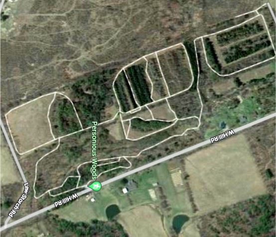
(Aerial view is a copyright of Google Maps Images 2022)
Unfortunately, we do not have the mileage for the trails nor the topo lines of our Gleason Map. (We are looking for volunteers to make a better map!) But all told - you have to walk ALL of the trails to get about a 5k loop. There is diverse habitat: a stream, meadows, mixed forests.
Dogs are welcome at Personius Woods. Please keep them on leash, and carry out their waste.
We have snowshoes for rent, for kids and grownups of all sizes! Snowshoeing is an easy, healthy way to get exercise, have fun, and walk on top of the snowpack like so many of our native animals. Members receive a discount on snowshoe rentals. If looking to rent snowshoes with a group, please call ahead.
Snowshoes are easy to put on! Our staff will assist you in finding the right size snowshoe, and then you simply snap the buckles over your hiking boots/snow boots. (They snap on and pull tight, just like the bindings on snowboards or rollerblades.) Then you're off to adventure on the trails by yourself! Snowshoe hiking is independent hiking - we do not go with you unless it's a specially scheduled program.
- Rental fees for members of Tanglewood: $4/hour, or $12/day.
- Rental fees for folks who aren't members yet: $5/hour, or $15/day.